![]()


Click to enlarge | PDF with Index (Recommended) | PDF Without Index
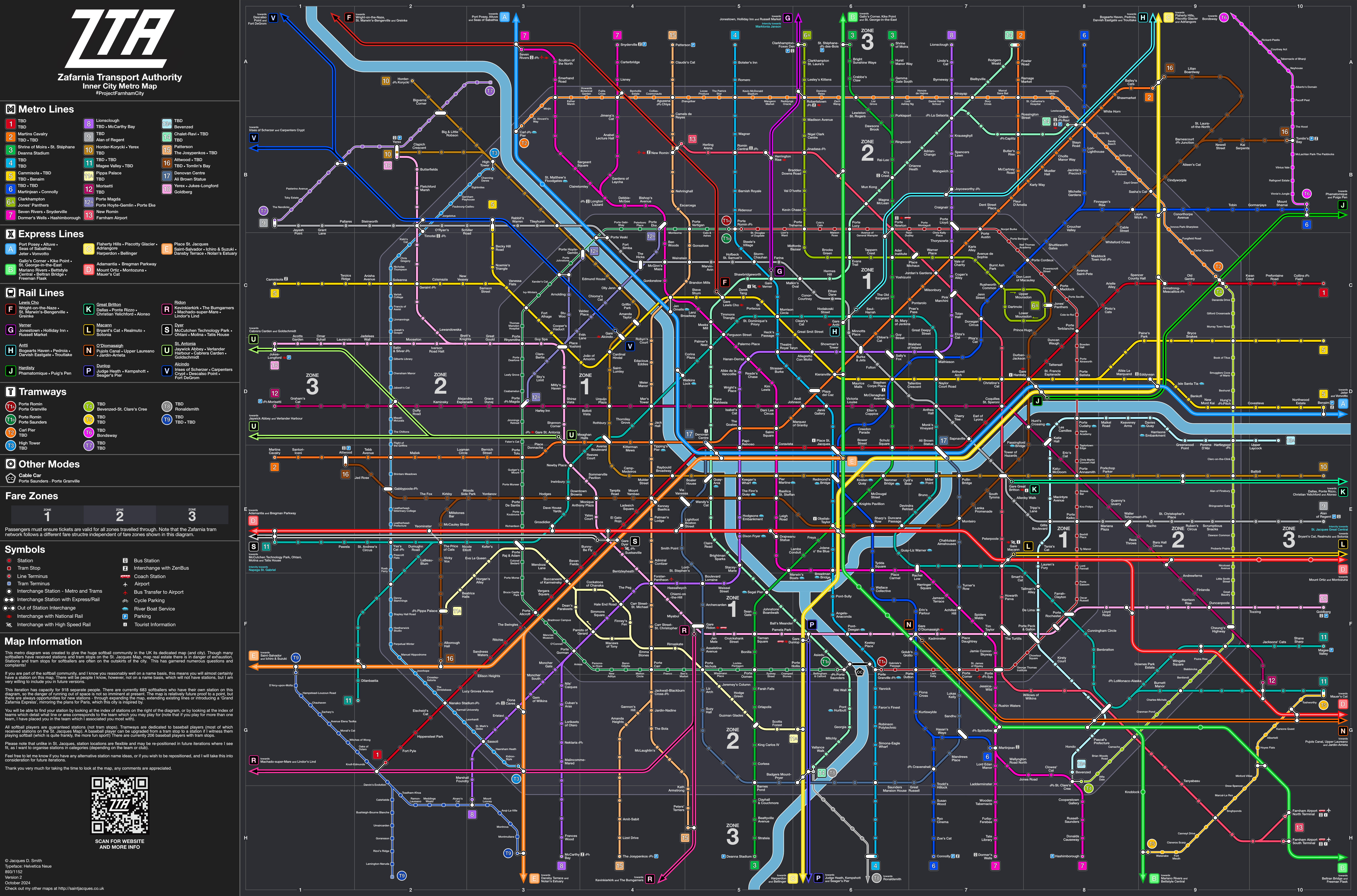
#ProjectFarnhamCity
Bienvenue a Zafarnia.
It’s yet another one of my fantasy cities. Go out and explore, there’s lots to see. A long weekend won’t scratch the surface of what Zafarnia offers. There’s tons of softball too, I hear.
Like the St. Jacques Map, stations are named after people. This version of the map has stations for 683 softballers.
It’s not primarily the cities I conjure up in my head, it’s the public transport system within. When I travel, my number one attraction is experiencing the city’s transport network! Drawn to metro maps themselves, I always collect them and make up my own.
The baseball and softball communities have been paramount to my life since 2012, when I officially made a pact with the bat & ball. Since then, I have not looked back. From the nerves of playing for a sports team for the first time, to the delight in making new friends and expanding my social circles, to the frustration of struggling to hit, to the dismay of being snubbed off a team roster, to the excitement of travelling to new places to play, to the bliss of drinks at the Finsbury after training, to the revelation of accepting my true self thanks to one of the UK’s best sports clubs, to the acceptance of my place in the outfield, to the drive to play more competitively, to the envy as other talented players getting to more competitive teams, to the absolute heaven of getting promotions, and the anxiety of upkeeping my reputation, softball and baseball have been a true adventure and I’m looking forward to the subsequent seasons.
From my official introduction to the true ‘beautiful game’ in 2016, with the Raiders (of which I am still a member), over the years I’ve had the fortune to play for many different teams and clubs, competing against opponents across the country and even abroad. To think I faced a team of US Air Force players as pitcher (scoring my very first home run over the fence, one of my favourite moments ever). I’ve crossed paths with many a softballer, and a few have become my dearest friends.
I’ve played softball for a decade now; nonetheless it is only really in the past few years where I’ve fully immersed myself in the community, with my ‘Year of Softball’ in 2023 which was an incredible year. With all the people I’ve met, why not commemorate this with a dedicated metro map?
Since I was young, I’ve imagined metro systems, where people would be honoured with stations named after them. It’s not until I was older when I decided to bring full transport systems into reality, straight out of my head. St. Jacques was the first full system I devised, initially from my days at university, yet continuing to be updated right to the present day. The map is currently almost filled, very few stations remain.
The softball community is extensive, and as more players filled the St. Jacques map, it got to a critical point where there were almost as many softballers on the map than the total people I met from university – at present 351 softballers vs 353 people from uni. Therefore, near the end of 2023, the idea long brewing in my head, I decided to devise a new metro system, to combat my boredom with St. Jacques, and to dedicate an entire map to the softball community. #ProjectFarnhamCity now under construction.
Needless to say, just like the St. Jacques map, stations are named after people.
I first released the map in March 2024: a 50% filled brand new map, entirely designed by me (with no influence from TfL). 496 softballers featured; map real estate was vastly available and up for grabs with 900 stops available. A turbulent 2024 season, with a new NSL team and 21 tournaments played, Version 2 expanded the list, with 184 new additions, bringing the total to 680!
Seasons are far too fleeting; another one has swiftly elapsed. Fewer tournaments played this year, down to 17, but the number of additions has surpassed the previous update! 214 new softballers have moved into Zafarnia, bringing the grand total to 894. That would have all but filled V1 bar six stations, though some expansions have been implemented as the map developed.
I cannot discount the influence the baseball community has had in my life over the past decade (and both communities are quite intertwined), hence there’s room for them too, along the city’s tram network. 209 baseballers have their place on this map, from the days of the Imperial Falcons in 2012 to my sporadic appearances at Finsbury Park in its autumn muddiness for Fall Ball. Inevitably softball has now completely eclipsed baseball, but the memories and tram stops will forever remain.
In total, since 2012, I’ve met 1,103 people through softball and baseball, the number is slightly more as there are a fair few people I know apart from their name. This is madness, I’m privileged to have been able to meet so many people.
894 softballers, 232 Raiders, probably over 100 teams represented: Zafarnia is the now the new cartographical home of softballers and baseballers.
I was hellbent on a phenomenal 2025 season after the thorny and uncurbed 2024 season. Demotion to NSL 3, almost relegated from the LSL Majors, and begrudging Gold. I focused on quality over quantity for 2025. More than survive Div 3, play more competitively – and get back to NSL 2!
Blue more than survived Div 3, we almost got ourselves promoted, imagine that. I made amends with Gold and looking forward to playing more tournaments with them in 2026. The shining jewel, of perhaps all my time in the beautiful game, is winning NSL 3 with the Fuzzy Ducks. My time in NSL has been a true escapade, it’s nice to be promoted for once. Hopefully next year in NSL 2, we bloody well will stay there, I have faith in our incredible team.
New Stations
I did not expect to meet this many people in the 2025 season! With my NSL and LSL teams locked down, not changing from the prior year (with only a few new players on each team this year), I thought the map additions would slow down a little bit compared to 2024. I was very wrong, the number added this year exceeded the number added in 2024!
214 new softballers have been added to the map. This takes the grand total to 894 softballers with stations on the ZTA network.
In total, this map now has representation for 1,103 people. It’s been a good 13 years!
Line Extensions
Plans for extensions were detailed in ‘The Story’ section of the website, to future-proof the map. Almost every individual line extension has been implemented for V3. This allows more space for stations (and some flexibility for placing stations in their relevant team. Space for 75 new stations has now been incorporated, though with the 2025 season, map real estate has quickly been snapped up.
God knows what I’m going to do for V4. If I meet even 100 softballers, the map will be completely filled up. I have some ideas involving expanding to a Zone 4 (and potentially Zone 5), which involves developing the Express and Rail line network, along with some outer city Metro lines akin to the Grand Paris Express lines 16-19.
Gridding
A very subtle change, but the map has been fitted onto a grid, so you’ll see a slightly neater look (if you can discern these kind of things). I can definitely observe a bigger air of neatness compared to V2.
Index and Teams
72 teams are represented on the map now, with their own sections. My experiences with each team have been updated for the 2025 season, in the new section ‘Teams and Sections’ on my website. A summary of teams and locations of their areas on the map are again briefly described in the index of the map.
Baseball teams and the tram network are better described in the index as well, being categorised by teams.
For the index itself, a new feature is a symbol which denotes which stations are also included on the St. Jacques Map (which itself has recently been updated with around 30 new stations. Check it out!)
A NOTE
Please bear in mind, station names may have changed, and stations themselves may have been relocated, to better fit into their corresponding team area. Consult the index to find your station!
Any comments are appreciated, feel free to message me on Instagram or Facebook. Thanks once again for taking the time to view my map, it means a lot to me to create these maps, this for me has always been an incredibly spiritual activity.