
Creating The Map
Running around the playground every breaktime was my sacred activity. I would pretend I was a Northern Line train, mindlessly bounding about the playground, stopping periodically. I needed a fantasy railway to complete the trainset, so I devised a tube line – where each of my classmates had a station. A new city was established - yet the name wasn’t ultimately decided. I often used the nickname Barbica to refer to the city.
The scope of the network clearly came from a boy with a wild imagination, with 1,089 lines in total. With only thirty students in my year group, they would not even scratch the surface in filling such an immense network. Barely any lines were drawn out – apart from the ‘Class Line’, a station for each member of my year group.

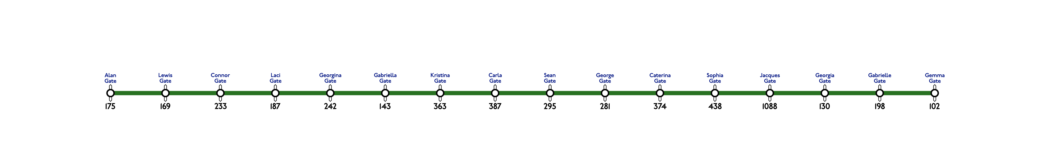
From memory, the Class Line and Wellies Line. It's been two decades since, so won't be entirely accurate. Click lines to enlarge.
The number below the station refers to the number of lines each station interchanged with. Essentially, Conapega but orders of magnitude more tangly and discombobulated.
Each student had their own line. Barely any were elaborated. The Marisa Line would have stations referring to all things horror, ghosts, witches, etc. The Marco Line was all things fashion. The Niall Line was Arsenal and football. The Sophia Line was majority equine. The Ciaran Line was motorbikes, amphibians… and flatulence.
Other lines were devised – the ‘Wait Long Line’ where trains sounded like washing machines departing the platform, waiting 15-20 minutes at each station – a frustrating customer experience. There was also the Wellies Line, which was the Class Line’s express service, serving all stations on the Class Line named after people who wore wellies on one of the school trips. Random.
I only remember drawing out the Class Line, Ciaran Line and Jacques Line on paper, long recycled (hopefully the recycled paper not ending up in a copy of the Daily Mail or Sun).
By the time I would enrol at Dame Alice Owen’s School, I was eleven, with a better grasp on reality. 1,089 lines ? Unrealistic.
The original Conapega map was birthed from a drawing on Microsoft Visio, a very useful diagramming tool, part of the Microsoft Office family. Primarily used for the creation of flowcharts and network diagrams, there were templates for street maps and metro maps. I rapidly mapped out my thoughts on the computer. This diagram became the base for Conapega’s Northern Line, which gradually evolved into a behemoth of a metro line, with branches galore. Soon enough, I'll try and recreate this from memory – as the original file has long been lost.
My dad often changed computers, getting the latest model when he could. On his next upgrade, Microsoft Visio was missing (and the installation disk mysteriously disappeared). The alternative was classic pen and paper. A3 sheets would be cut in half and stuck together with tape, forming my canvases for drawing out these lines with felt tip pens. The Bakerloo, Gabriel Glider, Jubilee, Northern and Piccadilly lines were completed. These maps were then rolled up and hidden in my room. Having a dedicated hobby was seen as untrendy; it would have been mortifying to me if people discovered I made tube maps. I fear my dad would not be impressed either, demanding that I stop this buffoonery and focus on my studies. At least what I was hiding was innocuous. Alas, I hid my geekiness, with Ecko hoodies, McKenzie t-shirts and Lacoste trainers.
The Metanet community got me into graphic design, so I would turn to… irrationally… Photoshop, to digitise my crude felt-tip line diagrams. Illustrator was right there, but I struggled to comprehend it. Downloading existing line diagrams from the London Underground, these were chopped up on Photoshop, using the clippings to create all the lines on the Conapega network. Definitely a crude and ham-fisted way of doing things; all sixteen lines were completed (in fact, the very last line, Jacques C, was completed a week before I started uni)!
Meanwhile, there was never an attempt to connect all the lines together to form the network. Each line was designed to have plenty of interchange stations, with no rhyme, reason or structure. The last line to be devised, the Heaselang line, seemed to be designed to make more stations into interchanges. It was only this year where I endeavoured to link them together. The results were as expected – entangled, illogical and shambolic. Mutated Manhattan on Steroids.
Speaking of which – a recent trip to New York City gave me a realisation. The structure of Conapega itself had been designed as an elongated, but narrow, city – on a north-south axis. There were generally four sections of the city (going west-east) – the beach side, two middle sides (one containing the financial district) and the mountainous side. Instead of the Hudson River, Conapega is borded by the ocean, with many beaches. The mountains replaced the East River on the eastern side of the city.
The Re-Design
I’ve been pining to design my Dame Alice Owen’s tube map for a decade. Gaining lots of experience developing the St. Jacques network, I ascertained very quickly that the Conapega map was lousy.
After completing the last exams at university, I would look forward to a two-month holiday. This time, I had no intentions of working or summer internships – this would be the final time I would ever have the luxury of such a long holiday (at least until my retirement or should anything happen to my health before then!)
Note that these days, I wouldn’t even think about taking two months off for summer – softball season is in full swing, and good luck trying to get a long period of annual leave in early July – one of the busiest times in the year for us train schedulers. Besides, I’m starting to prefer Corsica in winter compared to summer.
With no responsibilities and all the time in the world, Corsica is a great place to gain inspiration. Recently, it was in Corsica where I would do major work on the St. Jacques Map, significant development towards both the Zafarnia and Napega maps. In 2015, I was also delving into a potential redesign of Conapega.
During my 2015 summer holiday, the very last two-month holiday I would have until my retirement (if I made it that far, of course), I created a concept for a re-design.
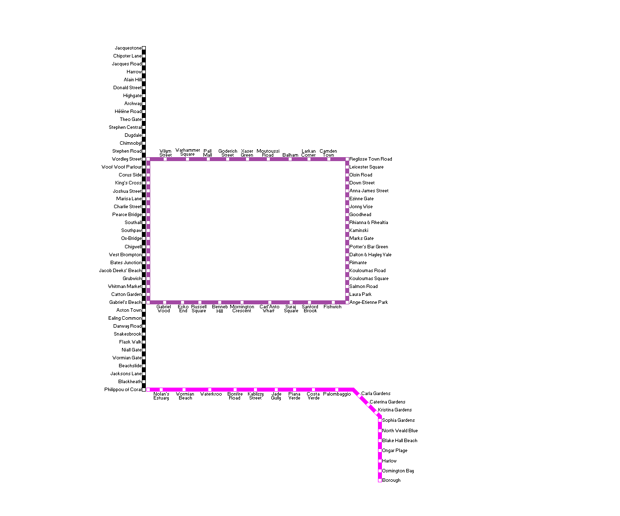
The original concept of the Conapega redesign. Click to enlarge.
Three lines were included, forming the base skeleton of the diagram. Two beach lines, one in original Northern line black, one in magenta – all with existing station names (primarily from the Northern Line). Introduced was a brand-new circular line, coloured in purple, taking inspiration from the prior completed St. Jacques map.
Attempts were made to add more lines to form the network, though I was never fully happy with the result. This concept would end up being abandoned temporarily. Focus was being put toward developing the final version of St. Jacques, the new Owens map was put on the backburner. Besides, I had now started a career in the transport industry – far less free time!
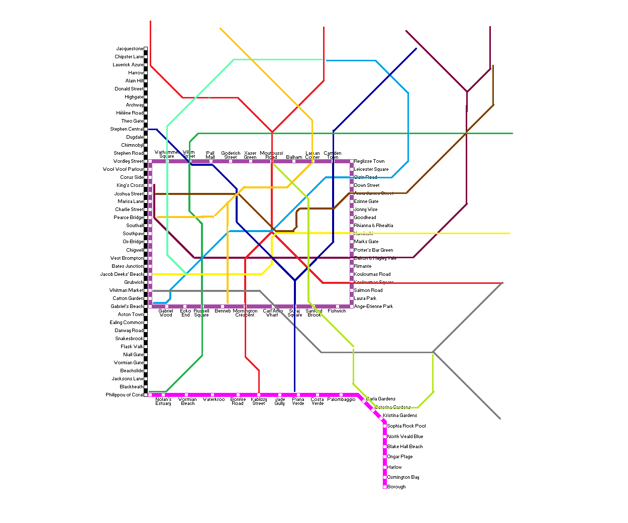
A few attempts were made to flesh out a full diagram, however these did not materialise in the end. Click each image to enlarge.
The project would not be progressed for a while, until 2020. Fishing out the original concept for the re-design, another attempt would be made to add further lines – however I no longer was keen on the circle line and two beach lines. Conapega was already a city by the beach, but I thought of a considerable resiting. By 2022, we were finally out of dreaded lockdowns, and I vowed never to take my sports for granted – entering 10 softball tournaments. Now on the second team of Raiders, I began to really immerse myself in the sport (bear in mind at this time I was still playing baseball regularly). The free time that lockdowns gave (if it weren’t for lockdowns, as much as I opposed and criticised them, I would never have been able to hand-draw St. Jacques) was no longer available.
With both the hand-drawn and digital St. Jacques map released, I received an unexpected message from a fellow Owenian. Paige told me that she really liked the map. She had her very own station, Paigecombe – added when I decided stations named after some of my closer friends from Owen’s onto the south-west area of the St. Jacques map, a particularly empty area. Paige had easily made that shortlist. I mentioned that a map for Dame Alice Owen’s existed, as well as my intent for its redesign. With at least one person from Owens being intrigued, I thought it would be the perfect time to really sink my claws into the project now that St. Jacques was finished.
The Conapega map did not include every person in the year. For the redesign, one of the goals was for each person to be included. The yearbook made it easy to compile most of the list – but only those who were in school until the end. I had to jog my memory to include all people who left beforehand (mostly after Year 11). A list I had made back when I was in Year 10, creating Waz Game II, where I also intended to include every student – allowed me to fill in most of the remaining gaps. List compiled, now for the names. Decisions on naming stations can take time; in many cases I used names from the original Conapega map.
The first iteration of the list was created in 2021. School days long concluded, the map was intended to be completely full from the get go. I remember my relationships at Owens. It was consequentially easier to develop a system for placing station names. Closest friends (throughout all eras of school) are prioritised for large interchange stations in the inner zone. More casual friends either end up as the remainder of the stations in the inner zone, lacking interchanges, or interchange stations in the outer zone. Acquaintances would be placed in the outer zone exclusively, those closer nearer the centre. I ranked all people in the year based on how close I was with them – and that would form a good basis for station placement. Nonetheless, the list laid dormant for years – other than an odd addition or change to a station name.
Preparing for a January trip to Corsica, another map was in the works. Sketches were promising, a list was ready, however this time, it was for a new fantasy city, dedicated to the softball (and baseball) community. Seven years after graduating university, the St. Jacques map was filling up, with few spaces available. Meeting new softball players at every tournament, I decided to create Project Farnham City – eventually being called Zafarnia.
Creating a new map was exciting. One of the key hopes was for the map to be devoid of any shred of TfL design influence. The Johnston typeface was banned. New logo, new style – hence its radical look, with bright colours popping out from the dark background. Dark mode is so popular; a lot of software now uses it as a default (including Affinity Designer!) One concept I intended for the map was to explore a different axis. Maxwell J Roberts’ book, Underground Maps Unravelled, shows many redesigns of the London Underground maps, using different axes and angles. It remains one of my favourite books. (He was the person responsible for designing the circular Underground map, which went viral last year). There was a particular elegance that the hexagonal map had – so I aimed to incorporate this into a future map. Click here to view this map.
The issue with a hexagonal grid was only having six directions instead of eight. You either sacrifice the horizontal or vertical direction, so it can make lines quite convoluted if you’d want to travel due north but chose to keep the horizontal axis. After some concepts were developed, I decided to stick with the octilinear structure for Zafarnia.
Still, Conapega’s redesign remained on my mind. During quiet periods at work, I would claim some sheets back from our famous tower of scrap paper (in my job, we print out a lot of things), and make initial sketches. I had ideas of creating a more logical city – one with an old town with many touristic districts with old monuments, an academic district with a reputable university, two financial districts (one in the inner city, one outside a la Canary Wharf), a fashion district, a high-class district (echoing Knightsbridge), a hipster playground, the nightlife area, and of course, the beaches. Those were a huge part of Conapega, so they had to remain. The city would be mapped out roughly, with rivers for reference, labelling these districts. The metro system would be there to serve it all.
A satellite city would be included – intended for Pope Paul students. This city would be connected by one or two lines from the main city. This concept was inspired by Madrid, and its MetroSur line south of the city.
I had a design concept for my new map too, preparatory work behind the scenes. I envisioned what I wanted the final product to look like. My intent was to use the Parisine font – which is used for the Paris Metro maps. Unlike in St. Jacques and Zafarnia, where lines are numbered or lettered, I wanted to keep Conapega’s attribute of having named lines, like in London. Conapega shamelessly took the exact names of seven of London’s lines. New names would be required, as I intended for this map to also have no TfL influence whatsoever.
The Gabriel Glider and Heaselang lines were the key to the answer. Lines would be named after people – my closest friends in school. Thirteen line names were eventually decided (keeping the original two from Conapega – Ross wasn’t a close friend but he’s made the cut due to station placements decided years ago).
Note: If I had more lines, potential names would be the Toondano, Mauripaige, Deane and Jones lines.
An early design style of the Napega metro, before the decision to go hexalinear.
The hardest part of creating a map are those initial sketches and plans. As the stack of paper lowered in height, I tried and tried to come up with a solid plan, but to no avail. Even in Corsica, I tried to drum up a basis to work on, however always seemed to either run out of time or produce something subpar. I had two holidays to Corsica coming up after the 2024 softball season – a week in October and two weeks in January – I absolutely needed to produce a workable concept within those holidays as there wouldn’t be another break until summer!
The October holiday signified the end of softball season, hence that week was mostly dedicated to version two of the Zafarnia map, which would gain some new features – an index and list of teams, as well as some fine-tuning and development, and the addition of stations for a crowd of new softballers. Affinity Publisher was trialled so I could easily include indexes for both Zafarnia and St. Jacques. A lot of the preliminary work was already done on Excel – a list of stations, zones and grid placements, so unexpectedly, I finished indices for both maps – and got Zafarnia V2 ready with a couple of days to spare, hence for the final days, I doodled some concepts on Affinity itself.
The hexagonal idea was revived, I made the decision to give Conapega the hexalinear treatment. There were two metro maps, which galvanised me.
The first map, created by TransitScapes, was an original representation of the Manchester MetroLink network. An exceptionally elegant diagram, most certainly hexalinear, National Rail services in the Manchester area were also included. Manchester, a brilliant city with an eclectic mixture of buses, has developed the ‘Bee Network’ – hexagons, from beehives, were adopted as a key symbol for the network – this map would have worked extremely well to promote the branding. This map drove me to conceptualising the original Conapega metro network with all lines connected, using the hexalinear axis.
Manchester’s Metrolink isn’t the largest, and has a small number of core trunk routes, congregating into a compact central area. Conapega’s redesign was intended to have a more considerable central area, with more lines. Anything I created would not match the refined aura of TransitScapes’s diagram.
Moscow Metro Map 2030 also provided some stimulation. Also hexagonal, the line also incorporates circles, as Line 5, the Koltsevaya line, is Moscow’s own rail inner circle. It is a good synergy of the two shapes. Central Moscow is more substantial.
Concepts converged towards an outer circle (formed of three connected lines). The inner circle wasn’t an original decision, but it formed naturally as line pathways through the city formed. It still took a few tries before something workable was produced – on the last night of my Corsican holiday. Still primitive, there was work yet to do – but one long holiday was approaching.
In the office, during a light period of work, I made further progress on the rudimentary diagram, and even before jetting off, the central area was well developed. Come January in Corsica, amazing progress was made. The list of station names was finalised, and by the end of the holiday, the full map had metamorphosed, also including National Rail routes, taking an idea from the TransitScapes Manchester diagram.
The next phase would provide its own challenge. I indeed had a map, full of placeholder stations. It was time for station placements. I had not decided which name would be assigned to each line, so had to start there. Ezinne and Olusoga were the obvious ones – both Pope Paul alumni, there were two lines connected into Barbica, Napega’s satellite city. I intended for the Kennaugh line to be the red line. I did have an idea on where to place some stations initially, which eventually lead to the final line name decisions.
Looking at the Excel spreadsheet with the list of stations (and rankings), I had a system in place. The map had an excess number of metro stations available, so there were second stations up for grabs.
With line names finalised, the person the line was named after would need their stations on that line. For example, Rushton Plaza needed to be on the Rushton & City line, and Sarah Parkinson Plaza had to be on the Parkinson line. Hence, these were the first stations placed – generally all high up in the rankings. Going down the list, interchange stations in the inner zone would be filled.
Certain people have received second stations (all in the outer zone) – again those with lines had to have their stations on their lines. That’s why the Awinnibelli has four stations, two each for Awinnie and Chiara: St. Awinnie-Napega University and Chiara are their main stations, with Belli of Avarin and New Inusa outside of London.
The map was to be filled completely – no placeholder stations. School is long over – there’s no-one to add (unless I have forgotten someone!) Teachers were added, none being present in the original Conapega map. National Rail stations would have names taken from the original map, to remind Napega of its roots.
Hence, with those foundations, gradually, with several iterations, everything was in place – now with just the finishing touches remaining to complete. Symbols, grid, index, presentation, zones – a complete map. Napega was officially ready.
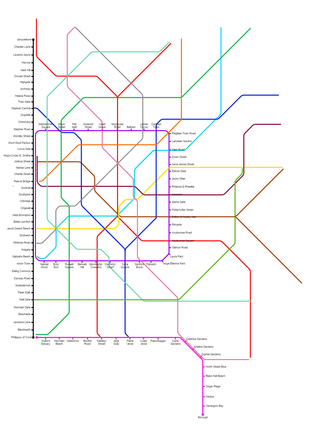
Whilst Napega was under construction, I was able to finish a small side project – where finally, the original lines of Conapega would be united into a full diagram. Not using too much attention to detail, it remains a fascinating curio demonstrating how metro maps should not be conceptualised!
I am very pleased with the final result. Napega looks stunning. The hexagonal trope is eye catching. The city is bustling. It feels far more personal than the original map, more of a celebration of a key era of my early life, with more dedication to my closest friends throughout this nostalgic time. It’s been a long time coming, but having it printed on A1 (the perfect size), I’m proud to have finally completed this in true style.