
The Story
It all started when I was a toddler.
My earliest vivid memory, that I still remember to this day, involved the tube.
The 1959 stock on the Northern line was still running, and the London Underground seemed like an uneasy environment to be in. However, it was not long until the 1995 stock trains were due to enter service. The new train was waiting for my mum and I on the platform at High Barnet. I somehow felt a lot safer on this brand new train. My mum and I used to go shopping at least once a month in the west end, so the tube ride from High Barnet to Tottenham Court Road was part of my early life. Each time, I would hope a 'new' train would await at High Barnet - but most of the time, the 1959 stock would be standing on the platforms. But the once uneasy environment became one of intrigue. I would stare at the line diagrams, wondering what all the stations were like. What’s it like in Morden? What’s interesting in Balham? I remember one weekend - there must have been engineering work on the Charing Cross branch, so we reached Tottenham Court Road via the Central line. At first, I was bemused - another Tottenham Court Road station? My mum explained to me about the concept of interchange stations.
My mum noticed my developing interest, so she began to bring back tube maps home for me as we picked her up from High Barnet station. I’d study them and see if I could memorise the entire network. I soon wanted to visit every corner of the map; from Heathrow, to Chesham, to Epping. I was most intrigued about the Waterloo & City line, constantly asking my mum if we could try it out together. My mum was the one who had to use the network during rush hour - so was far herself from being an Underground enthusiast. She was never happy to oblige to my wishes. We were to ride on the tube for as short time as possible - that was the agreement.
Every time a new tube map was released, my mum was sure to bring it back for me as soon as she could find one. I remember being particularly excited about a cover design celebrating the Chinese New Year, where dragons took over Tottenham Court Road, Oxford Circus and Leicester Square. I even day-dreamed about receiving it at school. Would the entire map be filled with dragons? I was a little disappointed that this very impractical idea was not implemented across the map, but it was such a cool cover that I didn’t mind. To this day I have most of the tube maps from about 2001, though there is a small gap in the collection between the time when my mum left England in late 2005, to riding the network with my aunt more often starting in 2007. My dad avoided the Underground like the plague, exclusively commuting via car.
I would go as far as to e-mail London Underground themselves, to ask questions that piqued their curiosity - they even sent responses back. This was back in the days where the internet was far different - the London Underground website even had a few games that people could play.
Here I was - an obsession with all things London Underground. Trips on the system were my treat as I endured shopping with my mum. When my dad offered to drop us off into central London on his way to work, I would throw tantrums, but my mum would always win in the end.
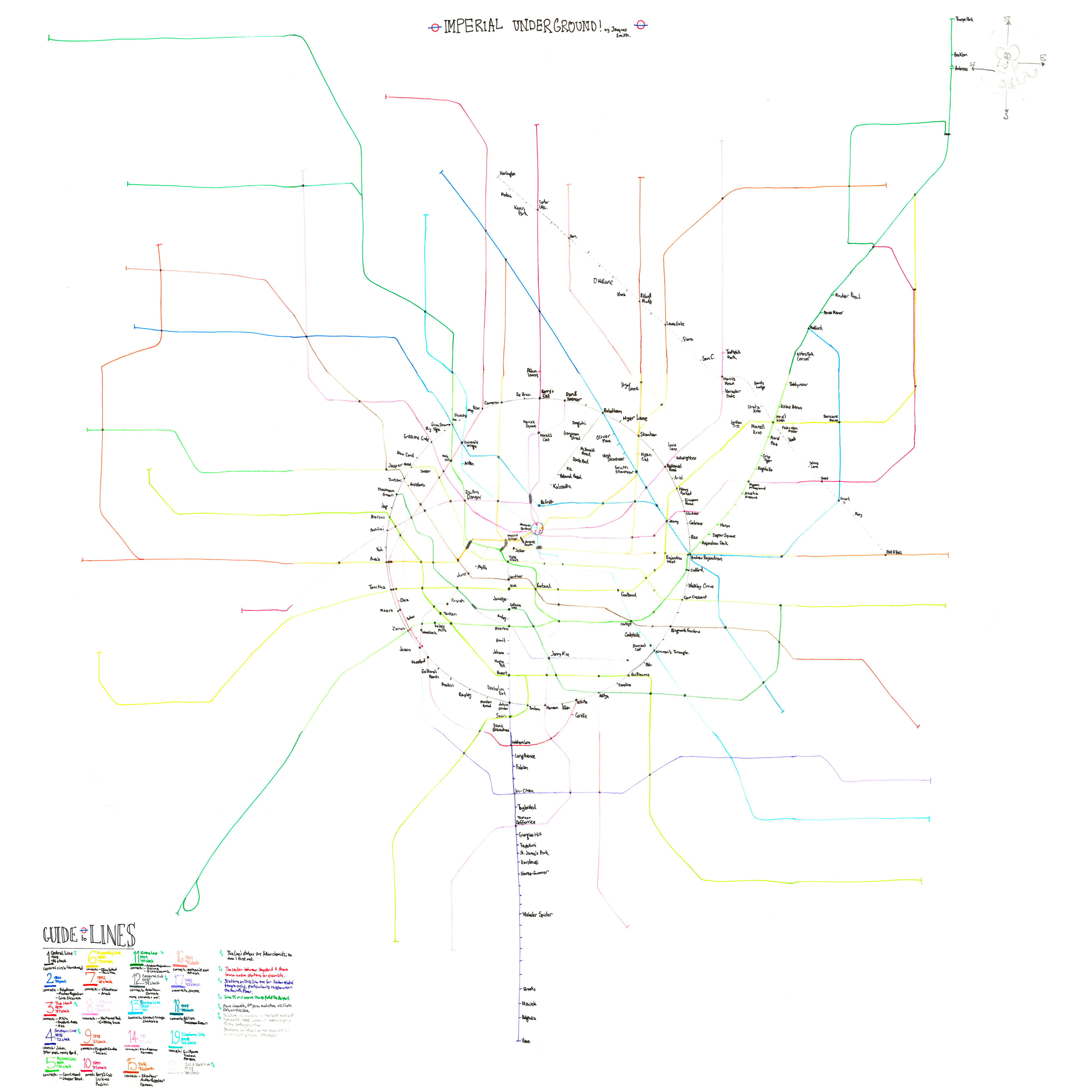
Whilst at primary school, I began to run around the playground aimlessly, pretending to be a Northern line train, during break time. Lunchtime was time spent with my friends, but the 20 minutes of break time in the morning was sacred - transforming myself mentally into a 6-car set of 1995 stock. I soon, stored in my imagination, developed a little tube system. (I may have drawn some lines out, but such drawings no longer exist). This tube system would serve my first fantasy city, to which I had never given a name. The city made little sense, with little thought on tourist attractions and general lifestyle, for instance, there were a lot of motorways, being another of my childhood obsessions. The city's metro system was a network of 1,089 tube lines. 1,089! Of course, this was all in my mind, and in actuality, only a small number of lines were ever fully devised. There was the Wellies line, the Wait Long line (with trains that sounded like washing machines and would stop for stations for a long time, for no reason at all). There were lines named for each person in the class, i.e. a Jordan Line, an Ezinne Line etc, along with a Ciaran line, with many stations named after gross things (that was his idea).
The most prominent line on the network was the Class line, running from Eamonn Gate to Gemma Gate. In school register (surnames alphabetically) order, each person would have a station named after them. The Class Line's rolling stock was the 1995 stock, of course. When riding the real Northern line, I would imagine I was riding the Class line instead (though I had to imagine the immense interchange stations, of course). To this day, 19 years later, I can still recite the school register in perfect order because of the Class line.

A recreation, from a distant memory, of the 'Class Line'. The main trunk mostly runs in order through the register of my primary school class. There were a few more branches, however I cannot remember where they went. Due to the sheer number of lines on the network, and with humongous interchanges, only the number of interchange lines are displayed at each station. Passengers would press the number, and a physical manifestation of a list of lines would drop down from the line diagram. A metro system of pure fantasy. Click to enlarge.
* * *
I can pinpoint one key moment where my interest in the London Underground further intensified. Whilst on an evening walk through Central London with my parents, I noticed a Routemaster bus on route 9, destined for Aldwych. Where was Aldwych? Was it on the tube map? As soon as I got home, I scoured my latest tube maps for an Aldwych, to no avail. I even looked at my National Rail map as well. I checked the station index but there was no entry. Where was this mysterious Aldwych located?
I did some research on the computer and soon learned that there was once an Aldwych station on the Piccadilly Line, which closed in 1994. I saw pictures of the disused platforms, and discovered that there were plenty of abandoned stations on the network. Down Street, British Museum, City Road, amongst others. On my next trip to Tottenham Court Road, I would remain especially concentrated between Kentish Town and Camden Town, to see if I could spot the abandoned platforms at South Kentish Town station. ‘There it is Maman, South Kentish Town station’. My mum smiled, but remained uninterested.
I would read through the entirety of the Abandoned Tube Stations website, and Nick Catford’s 'Hidden Stations' website (sadly no longer live) which went into more detail about the ghost Piccadilly line stations. I was a little spooked at the photos of the dirty, dusty abandoned platforms. The black-and-white photos from the 80s on the Abandoned site were very haunting; I even had a few nightmares about being left at these platforms alone. Frankly, the Underground was still somewhat disconcerting to me even with its great intrigue.
One thing I absolutely hated was the DLR between Bank and Shadwell. For some inexplicable reason, that section of the DLR utterly creeped me out, so much that I never looked forward to the Disney on Ice shows at the London Arena, as I would have had to take the DLR! I should have asked my mum if we could catch the DLR from Tower Gateway instead, but complicating journeys would be met with stern refusal - especially with the added fact that Tower Gateway trains almost exclusively run to the Beckton branch!
I got over my fears eventually - I saved the pictures, and made my own personal website (it never went live - it contained photographs from Nick Catford's website and the Abandoned Tube Station webpage, and I had not asked permission). Characters from the Winnie the Pooh universe would take visitors on a tour of each abandoned tube station - with Piglet often providing commentary on the 'creepiness' of the surroundings. I did show the website to my teachers, who were impressed (Mrs O'Connor, the scariest teacher in my 14 years of school by a wide margin was particularly pleased). Throughout my childhood, I would receive plenty of books for Christmas and birthdays about London's transport network, including one about the abandoned stations. I have kept every single one of them - hopefully when I buy my own place I'll be able to get a bookshelf so they can be proudly displayed, instead of stuffed in plastic boxes.
* * *
Embarrassingly, I continued with my spiritual train game during break times in the first term of secondary school. I never did catch flak from potential bullies for this, but as I began to fit in and make more friends at Dame Alice Owen's, it wasn't very long until that desisted. Instead, I would create a brand new tube network for my new school.
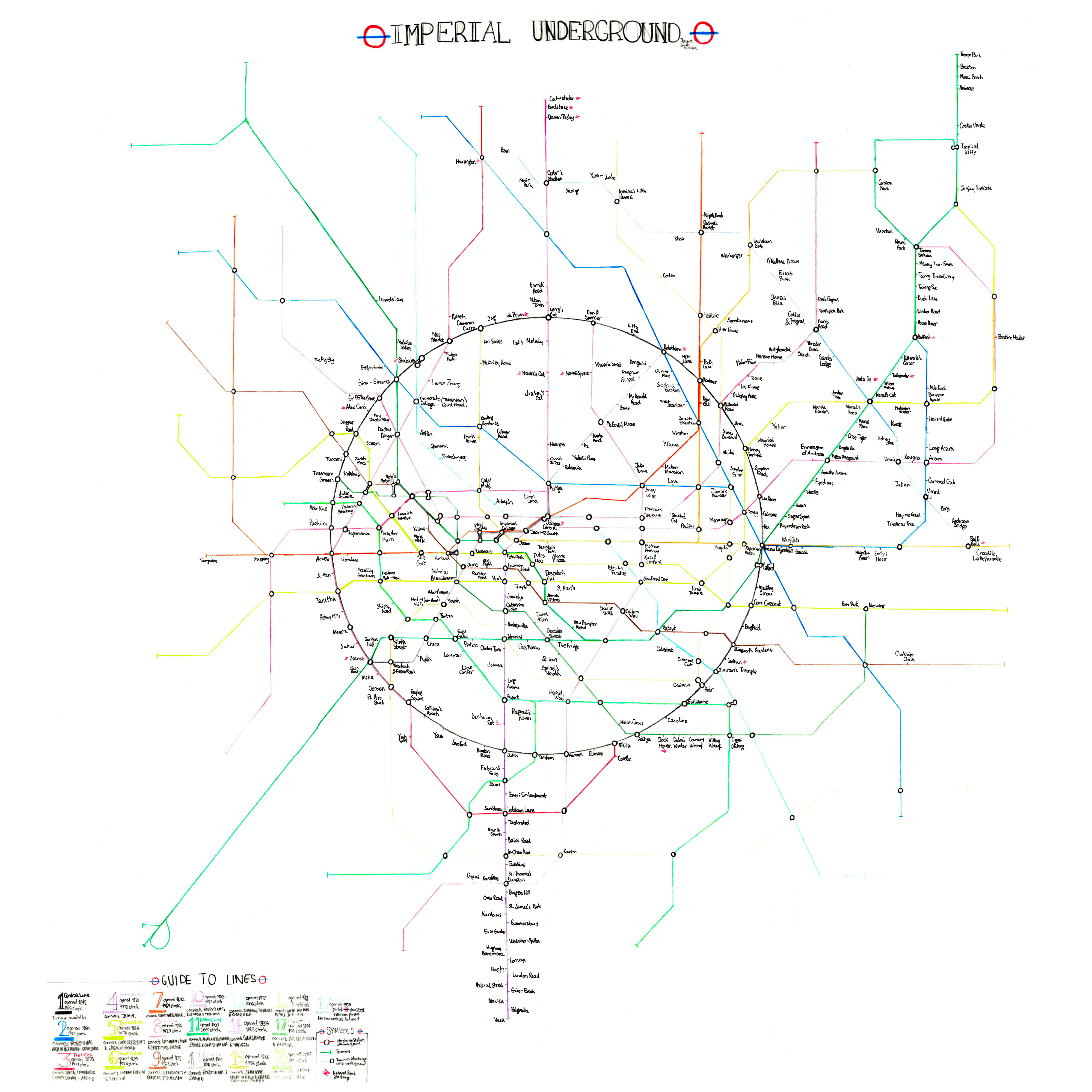
Mirroring the Pope Paul School network was not viable, with 200 students in my year group, a 'Class line' with 200 stations was unrealistic. Being older, I was less fantastical - a 1,089 line network for a city was sheer absurdity. The network for Dame Alice Owen's was a little more grounded in reality. The network eventually ended up with 15 lines (generally with an average of 60 stations), and a not very fleshed out Overground and DLR network. A tram service was merely alluded to, but never drawn. The city of Conapega was born (now re-named to Napega). There are images of some of the lines here.
One night, I drew what would become Conapega’s first established line - the Northern line, on Microsoft Visio. I wasn’t very imaginative with my names - most lines on the on the network were named after existing Underground lines. I would begin to hand-draw the maps of each line on paper. Soon, I learned the basics of Photoshop, and decided to draw the rest of the lines digitally, transferring existing lines drawn on paper to digital versions. I admit that Photoshop was an odd choice to use, now being more versed with vector illustrating software. To create the maps, I took existing tube line diagrams, chopping and pasting sections to create Conapega's lines. I ended up destroying all paper copies of the map (as I was a little shameful of this hobby). I am rather disappointed to have done this - these hand-drawn maps could have revealed more of the story of the map's development.

Never let your ardour cool for the honour of the school.
The problem with Conapega was that the so many stations had interchanges. Napega was designed to be quite a long, thin city, continuous beaches adorning the west. It was all well and good having all the lines ready, but try and put them together and you’d end up a right mess. Even putting two of the lines together would be a contrived exercise.
Just imagine putting the extremely complicated Northern Line and the Heaselang into one diagram. The Heaselang line will completely zig-zag and spiral around the Northern Line. Image this with 13 other lines, along with an Overground and DLR service. It just doesn't work at all. Case in point:-

An utter mess. This is why you don't plan your lines separately before putting them together. Napega is long overdue for a redesign.
* * *
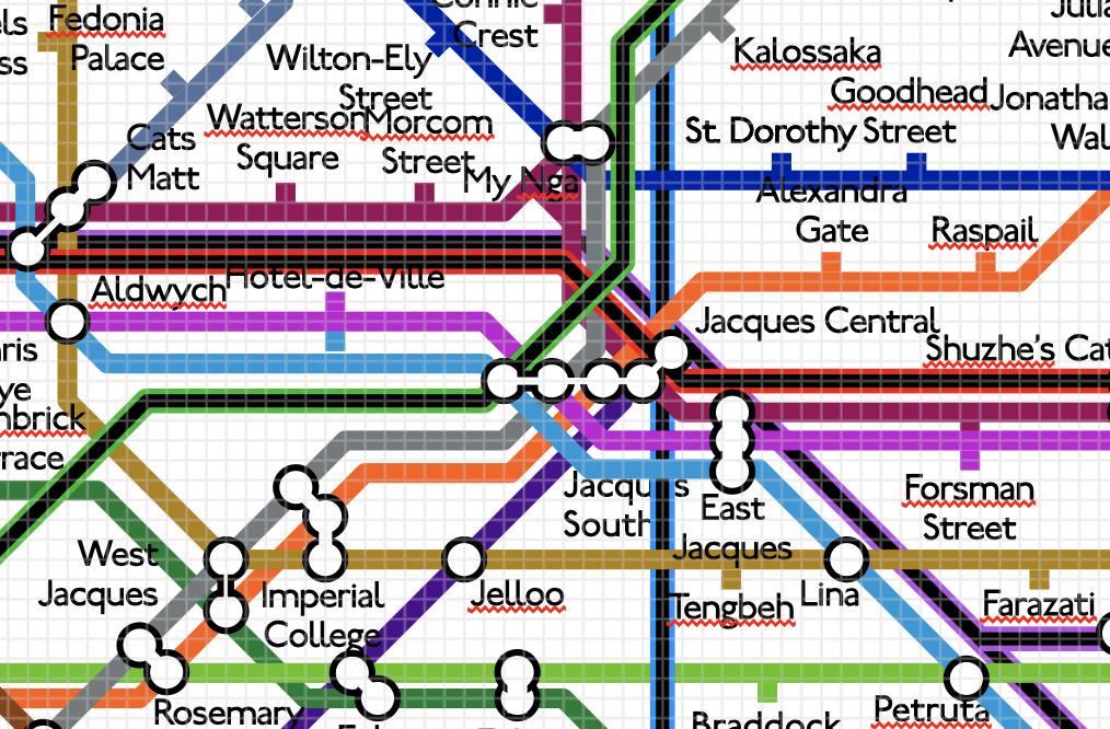
One trip provided particular inspiration which ultimately resulted in the creation of St. Jacques. The French Exchange trip in 2011 (a bloody fantastic school trip) took me and some classmates for a week in Paris. We stayed in Franconville, coincidentally twinned with Potters Bar, the location of my secondary school, this may have been intended...
Being French myself, I'm sure my exchange, Adrian, was relieved that his exchange was someone who he could hold a full conversation with in French. On arrival, we spoke about the week ahead, and he was extremely bemused when he discovered that on the top of my bucket list for my week in Paris was riding the Paris Metro. I visited this beautiful city numerous times prior, so had already crossed off most landmarks. During those trips, we never took the Metro; my mum was deathly afraid of it after once observing someone getting assaulted (and eventually having all their clothes nicked) on the opposite platform whilst waiting for a train, hence we always avoided taking the metro, instead travelling by car. To compensate, my mum did give me some old metro maps which I studied profusely.

I was more concerned with trying to get a Metro ride than seeing the Eiffel Tower.
The Paris Metro carried much intrigue, and it still does to this day. It expands at a rate far faster than the TfL network, with new tram lines and extensions to existing Metro and RER lines being a common occurrence. The Paris transport network evolves at a far faster rate than London's. I often take trips to Paris (thanks to the nifty Eurostar discount as part of my work benefits) - specifically to ride the network, purchase French food to return to England, and visit friends who live in Paris.
This trip would have been a good opportunity to truly discover the metro. My dream situation would be a day with him trailing along... where I ride every corner of the metro (I was particularly intrigued by Line 3bis, a four-station stub of a line whose purpose is solely to fill in a gap in the eastern extremities of the city). Realistically, that never was going to happen, and in hindsight I wouldn't want to subject poor Adrian to such an expedition.
Franconville was not on the Metro, being in the Parisian suburbs. Franconville-Le Plessis-Bouchard was a stop on the RER/Transilien network, on Lines C and H, in Zone 4 of the city. Note that the Paris Metro generally stays in central Paris only serving a handful of inner suburbs. I tend to be far more interested in the Underground than in National Rail services (though my interest in the latter is getting bigger) - so the RER was more of a consolation prise - though I still was intrigued. During the trip, we mostly stuck to RER Line C, with an occasional ride on Line H for a quicker route into Paris. On these lines, double-decker trains plied - which was quite a novelty - there is no such thing in the UK.
On the Saturday, I had an opportunity to hang out with Adrian, as well as my friends and their exchanges.The other attraction that I mentioned in my itinerary was Paris's Science Museum, so Adrian and I went there to start the weekend off. Nearest station was Porte de la Villette - line 7. No RER lines stop near the Cité des Sciences et de L'industrie (Rosa Parks station on the RER E Line had not opened yet). Adrian had no escape (my plans were fruitful). I finally got my retro ride. We made it to Gare de L'Est - only to be very disappointed with the dirty, drab, dreary, depressing MF 77 trains. I was shocked with how backwards these trains seem to be - especially compared to the brighter, cleaner rolling stock of the London Underground. Line 7 seemed to have haunted me - as subsequent trips to Paris always involved this line - a trip to Paris with friends from university (where unfortunately I only ended up with a bloody cold so was miserable the entire trip!), we booked a hotel just outside Tolbiac station. The next trip with my now ex-boyfriend... who had a friend with an appartment... that happened to also be in Tolbiac. By a crazy coincidence, the hotel and apartment were virtually across the street. Tolbiac is a station on line 7... so yes, more MF 77 rides. I have now grown to appreciate the 'Metro Blanc' as the MF 77 is often referred to as - especially as many of them have now been refurbished with a much brighter interior. I do like the relaxing hum they make as they trundle along.
Adrian could sense I was rather let down with Paris's metro. The MF 77 wasn't the best introduction. He thought 'with all of what Paris offered, this is what you want to visit?' But all was not lost. After the visit to the Cité des Sciences et de l'Industrie, Adrian and his friends (and thus their English exchanges) wanted to meet some of his friends near the Champs-Elysees. We had walked to a station on Line 5 (I can't remember off the top of my head - it may have been Ourcq). The trains on line 5, at the time running MF 67 stock, were much more pleasant, retro even. These trains happened to be a decade older than the MF 77s of Line 7. We would ride to Jaurès for the interchange with Line 2.
Line 2 was a completely different experience. Plying the line were the newer MF 01 trains, which made a satisfying screech (reminding me a little of the 1995 stock on the Northern Line). This section of line was above ground, suspended on viaducts. This allowed viewing the architecture of Paris at a new angle. Nothing of the sort existed in Central London. I began to fall in love with the Paris Metro. Whilst everyone was chatting, I was looking out of the window, concentrated on the motor noises.
I don't think we made any more rides on the Metro for the rest of the trip - but that was more than enough. I thanked Adrian at the end of the day as we reached his house, late on Saturday night. On Sunday, we took a trip to the Pompidou centre, one of Paris's landmarks I never visited previously - this was actually a ploy to get a ride on Line 11. However, this was thwarted as in actuality, it is a short walk from the Forum des Halles - so we took the Transilien Line H and one of the RER lines passing through Châtelet-Les Halles. The ride on Line 11 was redundant. Rats.
I bought a book - Metro Insolite, to expand my knowledge. I also took several copies of the Paris metro map back home, with a view to study the network. I liked the simplicity of the lines being numbered instead of having names. I would plan to take a trip back to Paris with the sole purpose of network bashing, trying out all the trains. Lines 3bis and 7bis were on the top of the list.
The French exchange had an effect on me - I believe after the trip I wanted numbered lines on my network. Conapega was however fully established. I believe it is at this point where the convoluted and underdeveloped Overground service came about - if you notice on the older Conapega line diagrams, interchanges with Overground lines also specify a number. TfL implemented this idea almost two decades later for their Overground network.

Not quite the metro - but the RER was quite intriguing. That ticket's invalid.
In all honesty, I don't like the Paris Metro map as much as London's, even though it was a source of inspiration. I don't like the drab colours chosen for many of the lines. I also don't like station names on top of rivers, or on top of the lines themselves. I don't like lines that bend too much. Paris Metro's map has all of these features, my maps avoids them. Harry Beck did a beautiful map for Paris after creating his iconic Underground map. It was unfortunately shunned by the city.
(P.S. Yes, Adrian does end up with a station on this metro map for putting up with me for two weeks, and for his little contribution to inspiring me to do this map).
* * *
I would be accepted into Imperial College London, and October 2012 was the beginning of my first term. I fit in far quicker in university than I did at secondary school. I was very much glad to leave secondary school by that time. Year 13 was not a particularly fun time, and not just because it was the final year of A-Levels. I was bummed out, in a rut, and looking forward to a change in lifestyle. By Year 13, all of my friends throughout school were studying other subjects. Year 12 had its moments, as I still had French class (and it was of course the year of my French exchange!) French was my least favourite subject by far of my A-Levels, but it was an easily A-Level to gain, being fluent in the language. I much preferred Maths, Chemistry and Physics. However, the people in my French class were amongst my best friends in the year at the time, so it meant that it was the one to look forward to within the 18 rather drab hours (though they had their moments)! We had a blast in French - I still try and keep in contact with most of my classmates.

Quite frankly, by Year 13, I wanted to move on to new things. Balloons can only take you so far.
Unfortunately in Year 13, I just didn't fit in very much with people in my classes - especially Maths, where I had 8 hours a week of lessons. What was supposed to be my favourite subject just ended up grating. I felt as though I was beneath my fellow Further Maths classmates. It sort of wrecked my confidence a bit. I essentially gave up on Further Maths, obtaining a grade C - especially as my conditional offer did not require a fourth or fifth A-Level.
But a new environment, and a new start! New people to meet. I really enjoyed university (though squandered the first term and a half of uni as I was a little scared of nightclubs). I was so excited that I met up with a few of my coursemates before term officially started (and those people ultimately ended up with some of the larger stations on the map as a result).

Uni was a breath of fresh air and I never missed a pub crawl. That being said, these were the days where I thought that jumper from the dregs of Camden Town was acceptable wear outside of the house.
Early on, I wondered if I should continue traditions, and devise a tube map including all the people I was meeting at university. I rejected the idea at first, thinking that I was too old for that silliness now. I'm officially an adult, with an opportunity to achieve an incredible degree at a reputable institution. It was time to knuckle down on studying and getting the grades, instead of dreaming up silly fantasy cities like a child.
That didn't last long, initial planning for a new metro network began. This time, I would scribble out the network in its entirety to start off with, doodling using different coloured pens, instead of creating detailed lines individually. This meant I would ultimately end up with a coherent, realistic network. Plans were to have 20 lines in total, numbered just like in Paris. Key to the map was a Circular line encompassing the central section of the city. This initial sketch led to greater things.
I go into more detail on the history of the map and sketches, alongside with my time at university in the 'Old Maps' section of the website.
* * *
One rainy Sunday in November 2012, the first edition of the map was created, in a very short amount of time. Originally kept to one sheet of A3 paper, I decided to draw the rest of the map on other sheets of paper, which would be affixed together on a wall to create the entire map. Unfortunately, the centre page was in drawn coloured pencil - and I did not bring them back to my halls, hence the rest of the map was drawn in pen. Lines were also drawn freehand, adding to a very primitive, scruffy map, There are two keys on the map - one in the bottom left corner, and one in the bottom left corner in the centre page. Stations began to be added within the circle.
Version 1 of the map - got to start somewhere.
It wasn't long - barely a month - before I created Version 2. I remember when drawing this one out, I had bad X-Factor auditions on to keep me amused whilst I was drawing. A larger circle was found in my house to draw around. This time, I used a ruler to ensure neater lines, giving the map a more professional appearance. This was the first version I showed to friends and they seemed to be rather impressed with it, surprising with how amateurish it was. But it was progress.
Version 2 of the map - turns out rulers make things look more competent.
At the end of the school year, right before my exams, I contracted chicken pox. It was a very mild disease but I was advised to remain inside as much as possible to prevent infecting other students. Luckily, I had plans to develop the map, and during my previous visit home, I had luckily drawn another large circle on pieces of paper, and had brought them back to halls. Using this time inside, I decided to redraw the map yet again - this would be Verison 3. It wasn't the most innovative diagram - but I improved the presentation of the map, using thicker lines and implementing a ban on tippex for any future changes. design features to make it look neater.
Version 3 of the map - thicker lines are a huge improvement visually
Between version 3 and the next version, I had attempted to create the map on the computer - one using Beno's map creator, (a tool that has proved useful for map developments, but doesn't produce the most attractive looking maps) - and one using MS Paint. These were the first digital maps. They can be viewed within the 'Miscellaneous' section of the website.
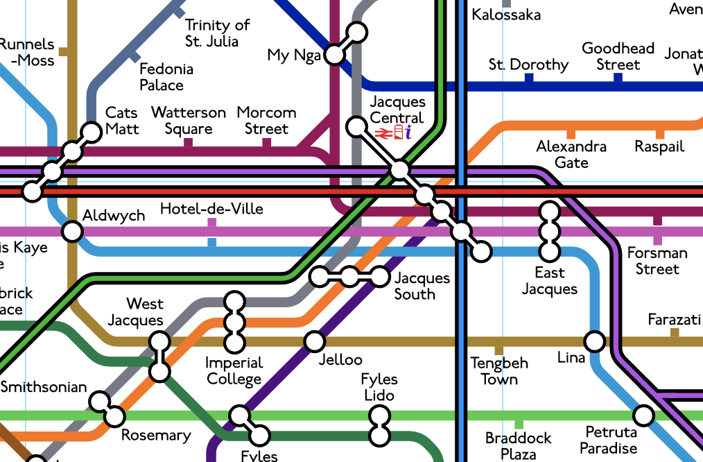
There was one problem I had metro map. A network with only one transport mode was unexciting. London has the Underground, Overground, the DLR, the Elizabeth line, a tram network and even a cable car. Paris has the Metro lines, the RER and Transilien, and many trams. St. Jacques, in the days of Version 3, only had the Underground. Studying version 3 closely, there were parts of existing Underground lines which could be obvious candidates to develop a potential Overground network, firstly an outer circle line, just like in London.
The MS Paint map really came into its own, it was exceptionally useful as it could allow me to develop and sketch initial plans for the future Overground network. Just the Overground was not enough, I had plans to include a light rail service, much like London's DLR. The city above the rails was realised considerably in my head - in particular, the area of line 11 in the top-right corner, looking quite bare, was ripe for development. Obviously inspired by the Central line Hainault loop - this curious section of map had potential to become a sunny oceanside satellite city of St. Jacques, similar to Miami. It would end up being the second centre of St. Jacques. One Underground line simply wouldn't be enough - so I proposed to increase transport connectivity by developing a light rail network there.
There was another problems arising too - At the start of third year, I would meet an unusually large number of people. Compared to second-year, there was a boom in the number of people who joined the Baseball society. The baseball team's existing line was too short to include the new arrivals. I was also going to Dodgeball society events more often in third-year - and in turn, was getting to know the dodgeballers a great deal more. I had a section reserved for them in Version 3, however new stations needed to be added in this area to accommodate more people. I also had plans to finally add the river the river, only seen in the second sketch of the map.

The Falcons after beating UCL yet again. As Imperial always does.
The list of proposed changes to the map was long - and would be a challenge to incorporate. Thus, I went down the route of creating a first draft, which proved to be an extremely wise decision. The map would also increase in size, being upgrading from an A3 centre page to an A2 centre page. By the end of October 2014, the draft was finished.
It wasn't until February 2015 when I started to draw the final version. I just didn't seem to have the time, being a regular member of two societies - and even more social events, beforehand, but February was a notably quieter month in the social calendar. At this time, I also vowed to take studying more seriously, after experiencing failure with several exams during second year, this was something to be avoided in third year. I initially started with the centre of the map, finishing off the circle. So impressed with what I had done, I was excited to continue and eventually finish the next version. This took almost two months to complete - I distinctly recall spending small amounts of time on the living room desk working on the map. This proved to be a great stress buster and helped to partially alleviate the depression I was struggling with - not being selected for the baseball team, and the terrifying reality that university would soon be over for me, with no plans or jobs lined up after graduation. Version 4 was completed just before my birthday, in mid-April 2015. I am still very proud of this drawing.
Version 4 of the map - not so full when I finished it in 2015, healthily filled up before I started version 5.
The map was supposed to represent everyone I had met at uni, but it was still pretty empty when I graduated in 2015. My project didn't go as planned. Thrust abruptly into adult life, I wasn't looking forward to the future. I accepted that the map would remain quite barren, not expecting to meet many new people. To me, adult life looked quite stressful and mostly miserable. I did attempt to fill the map, by adding people from secondary school, people in Corsica, and people in my family (after a trip to the USA).

I partied hard at the end of third year, seeing as the future was bleak...
My first job out of university was with Tower Transit, one of London's bus operators, and everything changed. Life no longer seemed too bleak. I felt finally like an adult, knowing I could make it somehow. A new job meant new people to meet. Tower Transit quickly claimed a very neglected part of my map previously, the south-east.
Things just got better. With a stable job, I decided to get back into baseball. I joined the London Mets baseball club, and met a whole load of people. One of my new baseball teammates introduced me to the Raiders, an LGBT softball club. By the end of 2016, the map was looking a lot more full. I had never imagined I would need to add even more lines and stations to the map, until certain events in 2017 occurred.
In 2017, I realised just how many Raiders could join in a single year. The first Raiders section was a little slither of space in between the Mets baseball section and the section for my friends/family in Corsica. I had gotten very close with my Raiders teammates from 2016 so was going to many Raiders events as possible. A new section had to be made for the Raiders and they completely invaded the eastern side of the map (under the river). And even then, there just wasn't enough space! I explored adding a few more Overground lines as South St. Jacques was quite bare in comparison to the north. One line would be created for Raiders specifically - Line R - now known as the Raiders line.

You can fit Raiders on a softball bench, but you can't fit them all between Line 8 and Line 11...
The main driver to create a brand new map came in a form of a job offer from London Underground as a schedule compiler. Yet more space needed for the map. To celebrate this, I wanted my future timetables colleagues to have Underground stations exclusively - as we would be London Underground employees. Even Overground stations didn't cut it. The problem was - at this point, essentially all of the Underground lines were taken.
A feature of the previous maps was having a number of line terminating in Zone 1. Lines 14, 15 and 17 did not run past the Circle line on one end, line 12 was entirely within the circle. These lines were ripe for extensions. The extensions of these lines could house my future colleagues.
Around the same time, I was studying the Paris Metro map yet again. It had three things my map currently didn't have - three things I wanted to incorporate. A 'bis' line (a short stub of a line that seems pointless). An RER network and a much more rationalised tramway network. The 'bis' line was easy to come up with - transform a short stub off line 10 in Version 4 into a small line, filling in a gap within the diagram. The stub. The RER, which would become the Crossrail network, and the tram network, required extensive development before being implemented. I spent a few months planning specifications for both the Crossrail and tram networks - making a lot of use of Beno's map creator.
Not too long after, one of my Raiders teammates, Donna, noticed my maps and was very interested in them and my passion for London Underground. It turned out that she had a friend who was interested in the London Underground as well, working as a customer service assistant at an Underground station. We all met up, the three of us, for a walk around London. We ultimately ended up at the London Graphics Centre. At the shop, I saw coloured pencils, Large sheets of high quality paper (up to A0 size), as well as stencils. I had mentioned to Donna that I believed that the map needed more development. With Donna and I in the shop, we both agreed that it needed to be done, and I had a large burst of inspiration. I bought several sheets of A1 paper with a view to further increase the map in size. I quickly started to work on creating what is now the current version. I had a desk bought specifically for mapping that could fit an A1 sheet, and now it was time to finally get on with it. Drawing began in October 2018, and the first draft took a month and a half to create.

The first draft - messy due to heavy pencil work.
This time, I initially would sketch the map in pencil. For this version, I introduced a new method to increase the professional look of the map, using a protractor to ensure all angles were 45°. I then decided to colour the map - but the sheer amount of pencil was difficult to rub out and the colours of the map seemed more dull. It wasn't until April 2019 when the map was coloured. But this was always meant to be a first draft, never a final version.
There was plenty I was unhappy with, so I decided it needed one more iteration before the final version. 2019 however was a busy year for me. First off I had to move out of my beautiful room in Wood Green - which took a lot of time. On top of that, I had to captain a Raiders team. I was in a long-term relationship, and I played a heck of a lot of softball tournaments. Time for mapping simply wasn't there - until certain unfortunate events happened.
In December 2019, concerns ensured regarding a new virus. It eventually spread and the covid-19 pandemic was declared. By the end of March, the UK went into lockdown, which halted any social activity. Though a very depressing and scary time, the silver lining was far more free time on my hands, where I would resume old hobbies - game creation, and more importantly, map creation. Early on in the pandemic, I would fully develop the Crossrail network, and with this finalised, I would be able to implement this on future maps. I knew the panic would set, and days prior, I had returned to the London Graphics centre and bought good quality A1 and A2 paper, a new set of coloured pencils, some drawing pins and some string to draw a circle. This would be a perfect time to really move towards finally finishing version 5.
I'd hope this lockdown wouldn't last too long and after a few weeks, we could return to normal, but it wasn't until June where people could meet up in small groups. However, the map gave a relaxing escape from the madness. I was making good progress with a new draft, as I was not happy with my initial efforts - I strongly felt a second draft was needed. I started in the beginning of April 2020 and by the middle of the month, the new centre, with all of Crossrail, was completed. Unfortunately, depression got the better of me and this infernal lockdown just dragged on and on unnecessarily. Without my vices of baseball and softball, I was a wreck.
Fortunately, I moved in with a previous housemate to a lovely new house with a garden. This perked me up a considerably, giving me the zeal to press on. A good month and a half of work - and presto, I had finalised a second draft of the map. The draft was in pencil and I decided not to colour it in as it'd just be a waste of time.

The second draft - much neater, but lacking in colour.
On my return from Corsica, my 8-year-old laptop finally gave in. I needed to purchase a new computer. I decided to finally treat myself to a MacBook Pro, a reward for getting through the madness of lockdown (plus a lot of money was saved from not going out to pubs, clubs and restaurants). I grew up with Macs and really wanted something more suited to graphic design. Using the aging, bulky Sony Vaio laptop, which was unable to give a decent screen resolution (considering how large it was), was not conducive to creating anything graphically. Attempts were made on InkScape, but it was generally unworkable.
Dr. Maxwell J. Roberts is the master of experimental tube maps, authoring one of my favourite books: Underground Maps Unravelled. In this book he has shape-shifted the tube map in endless fashions. He was the person responsible for the viral 'Circular Tube Map' which went viral (I was an O.G. and was aware of the original version he designed a decade prior). Reading his book, for years I wanted to create this map digitally, so it was time. Roberts used Intaglio for his creations, a Mac only software package. Now with a MacBook in tow, as soon as it was set up, it was off to the App Store to purchase Intaglio. Not knowing how to use the program, I figured I would learn as I go along.
Intaglio was virtually nonfunctional. It constantly crashed - I could not get it working. A total waste of money. Plans scuppered, I had to explore other options, or settle for InkScape - which was at least free and could possibly work better on a Mac. Illustrator was out of the question - I thought I could get my dad to attempt to pirate a license which is what we had done in the past, but by then they had moved on to monthly subscriptions.
Affinity Designer piqued my interest - it looked more similar to Illustrator, without the hefty price tag. I gave the software a chance - I would knuckle down and learn as I go along with the 30-day trial. It was surprisingly easy to use, Illustrator had stumped me in the past. The first experiment was to trace over the hand-drawn sketched map using the software tools. Everything clicked, the trial map was completed - and I bought a license right after that. Affinity was the right choice - Intaglio simply didn't have all the features necessary for what I wanted to do intuitively (such as the creation of Overground double lines, for instance).
Taking a break from the map to enjoy the brief freedom, I made a start on the final version of the map in early November 2020 - when the dreaded second lockdown was abruptly implemented. A few days before, I had panic bought several more coloured pencils, of very good quality. I purchased stencils for the interchange circles, and a special coloured pencil eraser (that even rubs out pen). It was finally time to officially draw the next version. This was a very long process, which took months, even with the free time that lockdowns bestowed. The map was created in stages:-
1. The lines of the maps were drawn faintly in pencil, making it easy to rub out if any modifications were required.
2. Using the MacBook and Affinity Designer, I would take a photo of the map, and trace over the lines. From the output, I could envisage how the map would look finished. This projection could be annotated to make changes to improve the map - and also was a good way to determine the most effective way to arrange where station markers could be placed.
3. The improvements were incorporated back into the paper map - lines would be changed as required.
4. Certainly the most time consuming, but also highly therapeutic stage, was getting the mileage out of the many coloured pencils and getting those lines coloured. This took almost two months co complete.
5. The thickness of the lines were too inconsistent for my liking. Using photos and Affinity Designer, I would survey the map to ascertain which lines needed thickening.
6. The river, of note, needed colouring - an important touch of the map. This had to be done intricately - the flow of the pencils being undisturbed. Bad colouring would jump out of the page, and ruin the professional feel I wanted the map to have. The light blue pencil was almost reduced to the nib.
7. Stations would be pencilled in, again to confirm the best positions for these station markers.
8. Once I was happy with every single station's position (some were changed), it was time to confirm the stations in pen. This was also very therapeutic.
9. A key was required for map for users to distinguish between the 49 (!) lines. I always wanted to use numbers and letters within circles, but Version 3 taught me that unless it was done perfectly, it would look scruffy. A neater option was devised (similar to Version 4).
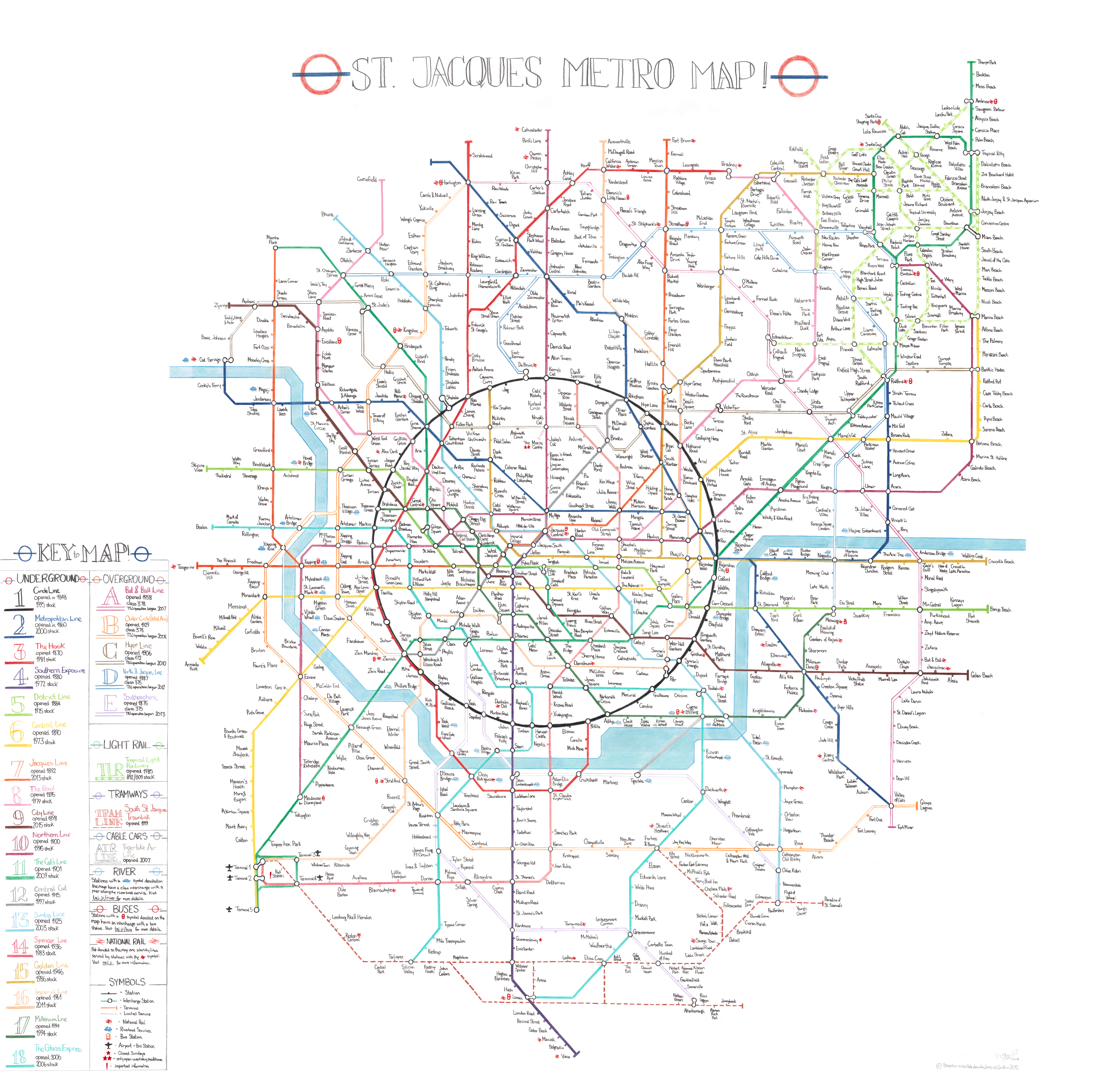
The map was finally complete, just days before my 27th birthday. I was so proud to finish my achievement. This map was years in the making, but hanging the separate sheets on my wall, I was so pleased to see the fruits of much labour and much prior planning. I debated adding a border, but I pondered framing the map - which would act as a much nicer border. A frame however will need to be custom made for this map due to it not being of a standard size.
The free time from lockdown, as much as I despised this era - allowed me to complete this project. May we hope there are no future serious pandemics so lockdowns will not happen again - but with that wish, I do not foresee the possibility of a new hand-drawn version of the map (which is needed as the digital map has some extra lines). I now keep the current hand-drawn map safe in a dedicated tube, awaiting my house purchase before proudly displaying it - don't want to risk ripping the map with taking it on and off walls using blu-tac (which tends to weaken the corners of the paper after a while). Versions 1, 2 and 4 have been ripped - not taking any chances with Version 5.
I had officially started creating the digital map in September 2020, in tandem with the hand-drawn map. The experimental digital map I created by tracing sketches was not viable. Lines were cramped, stations ended up on top each other. My handwriting is a lot narrower than standard digital text, so I could get away with a lot more on the hand-drawn map. The digital map had to be created from scratch!
 |
 |
I needed a break from cartography, and softball was returning - hence a lot of my free time was returned to my true love. However, I made small progress every now and again when I returned to the digital map.
A holiday to Corsica never fails to awaken my inspiration, and by August 2021 I was able to complete the first official edition of the St. Jacques Map - complete with zones and a grid. Corsica gives you free time aplenty - especially when some days, you don't have the means to get to the beach. The map was also printed and was hung in the kitchen of my old apartment.
It was intended to keep both maps in sync - however by 2022 I had decided to expand the digital map. It is a lot easier to do this on the computer than on a hand-drawn piece of art work. Two new Overground lines and three new tram lines were created - putting the maps out of sync - but it did mean more space for the future. You can only future-proof the map so much though, and the current version represents the map in its final form. There are still a few stations left, but I've become more selective with who gets on!
A representation of my life over the past 12 years, this map is one of my proudest achievements - and it very abstractly takes me through from my era of being an innocent student, the challenges faced - well into the map I am today. St. Jacques - we'll take you there!
With many thanks to the people who helped me along the way - and every single person which a station on the map - for being a part of my life.